
Investigación, Rutas
Guide to access La Huasteca
Introduction
This guide offers everything you need to know to visit La Huasteca in Nuevo León: from its geological history and current access after the passage of storm Alberto, to hiking trails classified by difficulty, practical advice, park rules and a look at environmental management problems. Ideal for planning your adventure with safety and ecological awareness.
Can I Enter in Car?
Basic Information
Hours: Open from 6 am to 4 pm
Location: Santa Catarina, Nuevo León, Mexico
. Cost: Admission to the park is free.
Activities: Outdoors. Hiking, mountain biking, climbing, etc.
How to Get There?
From Monterrey:
By car: The easiest way to get there is by car. From downtown Monterrey, take Constitution Avenue to the west and continue along the Monterrey-Saltillo Highway (Federal Highway 40D). At the height of the town of Santa Catarina, follow the signs to La Huasteca Park. Once you arrive at the entrance, you will find a free parking lot located outside the park, where you must leave your vehicle due to current restrictions due to the effects of the tropical storm
Public transportation: There are limited truck options, which make the journey longer. If we go from Monterrey Centro we can take Route 313 starting at the Benito Juárez stop and getting off at José Vasconcelos, where we will have to get on another truck. Then we will take Route 505 that will leave us at Circuit Valle B, finally we have to walk approximately 10 minutes to
At the entrance, you must register at the booth to access. There, the Tourism representative will request your personal data, the route you are going to and your access time will be recorded. This control makes it possible to better track visitors and facilitate their assistance in the event of a mishap.
Rules you should know before you go
Follow “Leave No Trace” in nature.
Bicyclists must wear a helmet and lights at night.
Do not enter motor vehicles.
Mandatory registration for camping and long ascents.
Business activities require authorization.
Do not damage flora or fauna.
Remove all trash.
Follow the instructions of the staff.
It is forbidden to light bonfires.
No alcohol or drugs.
Keep noise to a minimum.
Stay on marked trails.
Mandatory use of safety equipment when climbing and cycling.
Do not remove fixed equipment on climbing routes.
It is forbidden to feed wildlife.
Respect the direction of traffic on trails.
Vandalism and graffiti are prohibited.
Report emergencies to park authorities.
Do not enter with weapons or flammable substances.
It is very important to comply with these rules, as otherwise you may be subject to sanctions, expulsion from the park and/or legal action. This regulation seeks to guarantee the safety and conservation of the Cumbres de Monterrey National Park so that we can all continue to enjoy it. Many of the routes require physical and technical skills that may not be apparent at first. This is why the park's regulations are so important, since they not only seek to protect the ecosystem, but also to ensure that visitors can enjoy it safely
.Hiking and climbing routes
La Huasteca is a must-see destination for those who enjoy hiking and rock climbing. Given their technical and exposed terrain, it's crucial to take precautions and have the right equipment. If this is your first time, I recommend downloading Wikiloc, where you will find reviews, maps, points of interest and specific safety recommendations for each route, such as areas at risk of collapse, exposed sections or technical steps. In addition, it allows offline navigation, which is very useful since in many areas of the park there is no cellular signal. It is very important to recognize our limits to avoid accidents and to follow the internal regulations in order to continue enjoying these spaces.
Below I share a selection of routes classified according to their difficulty, with direct links to download the route on Wikiloc from our profile
: Beginners 1.
La Rayita
Ruta is short and physically accessible, although with some exposure in the final part. Ideal for those who are new to hiking. The ascent begins with high steps and ends in an area with panoramic views
.. San Bartolo Canyon
Awell-marked trail that leads to caves with impressive natural formations. It does not require great physical condition, but it does require crawling in the entrance and wearing a flashlight
and helmet.Intermediate
3.
. Mirador Nido de los Aguiluchos
Route with steep sections, loose stones and steps where the use of hands is required. A helmet is recommended due to the inclination and fall of stones. It offers one of the best views of the canyon
.. Pico Horcones
Constant climb with loose sections of terrain and a final climbing stretch of 3 meters. Ideal for those who already have previous experience and are looking for a moderate technical challenge.
. Cueva de los Batciélagos
Short but demanding route in inclination. It includes steps where hand support is required. The rocky landscape and the view from the cave make it an excellent intermediate option
.Advanced
Aguiluchos Sur
Demanding route with a slope of up to 1400 m and a duration of 8 to 9 hours. It requires a helmet and basic knowledge of rope climbing. High sun exposure; only recommended in winter.
I recommend that you check the comments and warnings within each route on Wikiloc. There you will find specific information on hazards such as sections with rockfalls, points of prolonged sun exposure or reports of the wildlife you are going to see
on the route.As a personal note, I would like to add that, due to the restrictions still in place, route times may increase. It used to be possible to reach the start of the routes by car, but now it is necessary to walk from the entrance, except for locals. For example, in Pico Horcones, this involves approximately an extra hour of travel and another hour of walking back. It's very important to consider this detail when planning your visit
.Best time to go
Spring would be the ideal season to visit the park because there are pleasant temperatures and open routes, with flowers everywhere. In summer, it's best to start early to avoid heat that reaches 37 degrees. Fall also has good weather for hiking and biking, as well as super colorful landscapes. In winter, the park is quieter, and some routes are closed due to the weather that can be very cold with temperatures of almost 0 degrees.
👉 Weather in Santa Catarina, Nuevo León
Controversy over its Management
The Cumbres de Monterrey National Park, established in 1939 and redelimited in 2000, faces serious challenges due to the lack of an updated management plan. Although a new management program was published in January 2023, its effective implementation has been limited, leaving the park vulnerable to various threats.
One of the main problems is the absence of unified management. Various authorities have powers over different aspects of the park: the municipality of Santa Catarina is responsible for its administration; the National Commission for Protected Natural Areas (CONANP) manages the land within the park; the Secretariat of the Environment regulates the activities that take place inside it; and the State Attorney's Office for the Environment is responsible for preventing illegal actions that threaten conservation, such as irregular clearing. This fragmentation has caused the park to be affected by illegal urbanization, with unauthorized constructions that
damage the ecosystem.Despite the fact that the park has only one official entrance, which in theory should facilitate its control, the entry of illegal materials for construction and debris disposal continues. This phenomenon is due to the lack of effective surveillance and to the corruption that allows trucks with prohibited materials to pass through. The authorities have shut down several illegal buildings, but these actions have not been enough to stop the uncontrolled urban expansion within the
park.According to a report by the Ministry of Sustainable Development of Nuevo León, 57,106 hectares were illegally dismantled from 2017 to 2019. This excessive growth does not contribute to the conservation of this valuable natural space and hinders efforts to protect it. The lack of coordination remains the biggest difficulty in ensuring the preservation of the park. It is crucial that, in the short term, stricter regulations are established to conserve this important ecosystem
.History
Today we are going to talk about one of the most popular places in Nuevo León: La Huasteca Park. This area is a paradise in all of Mexico for all nature lovers, due to its breathtaking views.
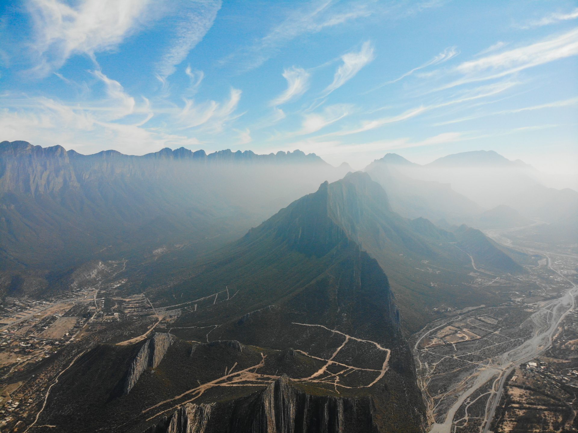
La Huasteca is part of the Cumbres de Monterrey National Park, created in 1939 and declared a biosphere reserve by UNESCO in 2006. It is located in the municipality of Santa Catarina, southwest of Monterrey, it is a natural canyon through which the Santa Catarina River flows. La Huasteca is characterized by its impressive limestone rock walls, which millions of years ago were marine sediments. These formations, which reach more than 550 meters in height, were formed during the Jurassic and Cretaceous periods, and their erosion has created this spectacular landscape that we see in the photo.
(references: https://parquehuasteca.org/el-parque/historia)
After the passage of Tropical Storm Alberto last June, significant damage was recorded, such as the loss of the main road due to strong currents. After the disaster, access to the park was temporarily restricted, allowing only local residents to enter. Nowadays, the park is now open to the public, although traffic is still limited only to the inhabitants of the area
.Here you can see the impact that the storm had on the existing road. To this day, work is still being done to keep a dirt road in suitable conditions for those who live inside the park
.It is very important that, when planning your visit, you consider that only residents are allowed vehicle access. Therefore, you will have to walk to the beginning of the path you plan to walk. If you are going on a long route, I recommend starting at the park's opening time (6:05am), as the journey on foot can take several minutes, depending on
the destination.This is how you will find the path you will have to walk, or if you are lucky some place can offer you a 'ride'.
Dudas
Done, now you know how to access La Huasteca Park! I hope you really enjoy your visit to this jewel that we have just a few minutes from Monterrey. Remember to contact La Cumbre Cotidiana A.C. if you have any questions. Below I leave you my email for any questions or suggestions, and as always, we'll see you on the hill
!email: [email protected]