

Preparación, Rutas
How to Hike Cerro de la Silla: Beginner and Advanced Hiking Routes in Monterrey
Introduction
Cerro de la Silla is Monterrey’s most important natural symbol. This guide shows you how to hike it through beginner-friendly options and more demanding routes for advanced hikers, always with a responsible and safety-first approach.
Introduction: Cerro de la Silla
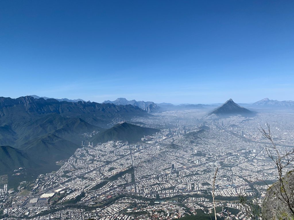
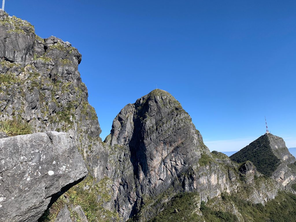
Cerro de la Silla is Monterrey’s most important symbol and one of the most recognizable natural landmarks in Mexico. Its unmistakable silhouette, visible from most of the metropolitan area, is formed by several main peaks that rise above 1,800 meters above sea level, with more than 1,000 meters of relief from the base.
Its steep limestone walls, deep gullies and proximity to the city make it a true “work of art” of nature and the perfect setting for those who want to start or progress in mountain hiking.
In this guide we explain how to hike Cerro de la Silla along its best-known routes: from beginner-friendly options like Teleférico and Pico Antena to advanced outings such as Pico Norte and Pico Sur with Loma de la Virgen. Always with a focus on safety, preparation and respect for this Natural Monument.
The Silhouette that Defines Monterrey
Seen from the city, Cerro de la Silla invites you to dream about its summits. Whether you are looking for your first mountain experience or a challenge that will test your endurance and technical skills, you will find a route that fits your level here.
Routes on Cerro de la Silla
Cerro de la Silla has four main peaks: Teleférico, Pico Antena, Pico Norte, Pico Sur and Loma de la Virgen (this last one as a secondary bump very close to Pico Sur). To reach them, most hikers use three main access points: the classic starting area in Bosques de la Pastora, Parque Hundido and the San Ángel neighborhood.
The most frequented route —and the one we recommend to start getting to know the mountain— begins in Bosques de la Pastora, in the area popularly known as Puerta del Sol. From there you can hike up to the old cable car station, to Pico Antena and also connect towards Pico Norte. The access from Parque Hundido is used mainly to reach Pico Norte, while San Ángel is the classic starting point to approach Pico Sur and Loma de la Virgen.
In the following sections you will find the routes we consider most suitable for beginners and those that belong to an advanced level, with a short description, approximate uphill times and quick recommendations.
Teleférico: The Best First Experience on Cerro de la Silla
The Teleférico route is the classic entry point to Cerro de la Silla. The path follows a well-defined trail and road that climbs steadily all the way to the old cable car station, making it an excellent option for hikers who want to experience the mountain’s elevation gain for the first time.
Along the way you’ll enjoy increasingly wide views of the city and several spots to rest. It’s a great route if you want to focus on the physical effort without worrying too much about navigation.
- Approximate distance: 5.2 km (out and back, depending on the chosen variant)
- Estimated ascent time: about 2 hours
- Quick tips: start very early or close to sunset, bring at least 2 liters of water, carbohydrate-rich snacks and a headlamp if there’s any chance of finishing after dark, since shade is limited during midday.
- More information: Teleférico (lacumbrecotidiana.org)
Pico Antena: Continuous Effort
Pico Antena is the most frequently hiked route on Cerro de la Silla. From the Teleférico path, the trail keeps climbing all the way up to the antenna along a steady line where the main challenge is to keep moving without long stops. Even though the trail is clear, the cumulative elevation gain, close to 1,000 meters, is very noticeable in your legs and breathing, so this is a demanding outing for those coming from beginner-level routes.
- Approximate uphill distance: 5 km (from Bosques de la Pastora to the antenna)
- Estimated ascent time: around 5 hours, depending on pace and breaks
- Quick tips: start very early to avoid direct sun, bring at least 3 liters of water plus some electrolytes, salty and sweet snacks and sun-protective clothing; pacing yourself is key to not burning out before reaching the antenna.
- More information: Pico Antena (lacumbrecotidiana.org)
Pico Norte: Unforgettable Views
Pico Norte is one of the steepest hiking routes in the state of Nuevo León. Whether you start from Parque Hundido or connect from the Teleférico path, you’ll face a relatively short trail in terms of distance, but with more than 1,100 meters of elevation gain over roughly 2.8 km of ascent. It requires solid aerobic fitness and strong legs.
From the summit, the views over the Cerro de la Silla Natural Protected Area, the other peaks and the Monterrey metropolitan area are something every local should experience at least once.
- Approximate round-trip distance: 5.6 km
- Estimated time: about 5 hours (can be longer depending on breaks)
- Quick tips: bring at least 3 liters of water plus electrolytes, a helmet, trekking poles, a basic first-aid kit and long-sleeve clothing due to high sun exposure. This is not recommended as a first high-demand mountain route.
- More information: Pico Norte (lacumbrecotidiana.org)
Pico Sur and Loma de la Virgen: The Most Technical Route on Cerro de la Silla
Pico Sur and Loma de la Virgen share most of the approach and are almost connected; Loma de la Virgen is usually visited as a short 10–20 minute detour from the main pass. This area is, without a doubt, the most technical part of Cerro de la Silla.
To reach Pico Sur you must overcome sections such as the well-known Paso de los Arrepentidos, where exposure to the void is very high and fixed cables and chains are used to protect some of the scrambles. There are no second chances here: excellent technical terrain skills, previous experience on advanced routes and solid risk management are essential.
- Estimated ascent time: around 7 hours to the summit (the full outing is usually much longer)
- Quick tips: recommended only for hikers with previous experience on exposed terrain. Bring a helmet, gloves, footwear with very aggressive grip, a short rope if your team is used to protecting delicate sections, at least 4 liters of water and enough food for a long day out. Absolutely avoid this route under rain or strong wind forecasts.
- More information: Pico Sur and Loma de la Virgen (loc.wiki)
The Sillología Challenge
For those seeking a major challenge, there is a well-known objective called Sillología, which consists of linking the four main peaks of Cerro de la Silla in a single day: Teleférico, Pico Antena, Pico Norte and Pico Sur (often including Loma de la Virgen).
This challenge combines long hours on the move with big elevation gain, technical sections and exposed ridges and traverses equipped with cables and chains. It is not suitable for beginners or for hikers who are only starting with intermediate routes.
- Recommended level: very high fitness, experience on advanced routes and solid skills on technical and exposed terrain.
- Minimum gear: helmet, trekking poles, gloves, headlamp with spare batteries, a first-aid kit, enough water (4–5 liters per person, depending on the season) and food for a full day out.
- Planning: always go with a strong team, carefully check the weather forecast, route track and potential escape points. This should be treated as a serious mountain challenge.
- More information: Sillología Challenge (loc.wiki)
Safety on Cerro de la Silla
Cerro de la Silla is as demanding as it is impressive. Before choosing a route, always check your fitness level, the difficulty, timing and weather conditions. We recommend that you:
- Avoid hiking alone, especially on advanced or technical routes.
- Tell a trusted person your planned route and estimated return time.
- Check the weather forecast and avoid days with rain, dense fog or extreme heat.
- Carry enough water, high-energy food, warm layers and rain protection according to the season.
- Respect all signage, conservation areas and always pack out all your trash.
If at any point a route feels above your level, do not hesitate to turn around. The mountain will still be there for another day.
Explore More Routes and Learn About Our Difficulty Ratings
If you want to keep exploring the mountains around Monterrey, we invite you to visit our route catalog, ordered from the easiest options to the most demanding ones:
Hiking Route Catalog near Monterrey | La Cumbre Cotidiana
You can also learn how we rate physical effort, technical difficulty and exposure on each route in our difficulty classification page: